")


Introduction: Usually special experimental installations are using for assessing the accuracy of determining the coordinates which obtained by various positioning methods and data processing technologies. Them also referred as systems of spatial displacements of the antenna phase center.
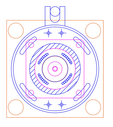
In this paper decried the designing process of an automated system of spatial displacement of the satellite geodetic equipment phase center. Purpose of work: development of an automated system of spatial displacements of the phase center of satellite geodetic equipment. Methods: in this course of work, studies were carried out for aiming at potential requirements for an automated system of spatial displacements of the phase center. There’re additional analysis of the design and purpose of existing systems as well as the development of a system. The results of this work was list of established requirements. Results: was presented the analysis of domestic and foreign experience in the development and use of such systems, their classification and the most successful technical solutions in that branch. The requirements have been developed for system technical characteristics based on the analysis of the tasks which potentially could be solved. The element base and the design of the system was selected and developed in accordance with the specified technical characteristics. The rotation of the antenna of the Global Navigation Satellite Systems could be made in a circle with a radius of 0 to 500 mm. In this case, the radius can be dynamically changed with an accuracy of 0.2 mm. In addition, the system allows you to change the position of the antenna of the Global Navigation Satellite Systems in height within the range from 0 to 230 mm with an accuracy of 0.05 mm. The developed system does not require permanent fixing and can be moved to the required area of work. The results of the work should be used to assemble a prototype of an automated system of spatial displacements of the phase center of satellite geodetic equipment. Practical significance: The developed system can be used to conduct kinematic tests of satellite geodetic equipment and conduct a wide range of studies within the framework of modeling the movements of a reference satellite geodetic station under conditions of anthropogenic and natural influences. Discussion: Further development of the system may include the determination of its metrological characteristics using methods of near photogrammetry